Bioregional State Talk in Chicago
Bioregional State Talk in Chicago
WHO
Mark D. Whitaker
author, Toward A Bioregional State
WHAT
Short summary of the book Toward A Bioregional State
WHERE
North Park Village Nature Center
5801 N Pulaski Rd, Chicago, IL
(312) 744-5472
Sunday, October 8, 2006, 2-4 p.m.
One hour talk, questions afterward
MORE INFORMATION
short two page flyer on Toward A Bioregional State
[TO GET THERE: go down main entrance; at first stop sign, take left; road curves around large building on your right; parking lot is there; parking there available; then walk toward the left once more down a gravel path into edge of the woods; will be going between some raised bed herb gardens and other wildflowers, and you are there at a one story brick building with a half flight of stairs to the main entrance]
[archiving advert flier for talk: here]
[Thanks to all who came.]
Introduction: A Waterway Tour Into Chicago
In googling up where this talk was going to be, I quickly became fascinated with what typically would be called a subsidiary point of the city: a nameless black waterway.
Through Google Maps, I virtually followed this nameless black waterway snaking into Chicago, sometimes sinuously, sometimes "streamlined" by human effort into straight lines. (Why do we use the term "streamlined" to indicate something that has lost typically all evidence of being a stream?)
I think this nameless black waterway can make a good introduction and an uncanny geographic perspective to some of the core issues involved in Toward A Bioregional State: such as, how do you organize sustainability? A history of Chicago's "cribbing" activities to get its water is a fine example and case lession.
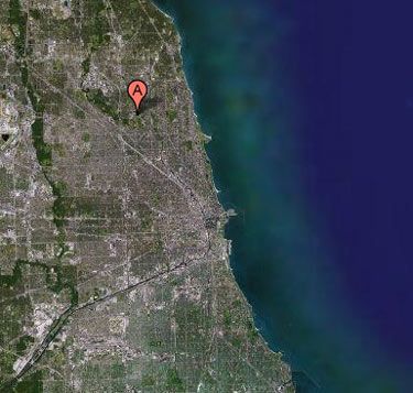
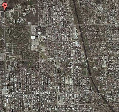
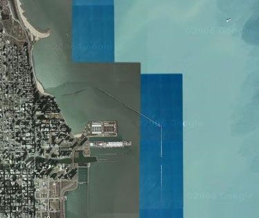
Winding and wending its way deeper into central Chicago, near the North Park Village Nature Center, is an unmarked waterway.
It may be called "North Branch" -- though the North Branch seems to be further west (in the left quarter of this image):

Definitely flowing into a northern branch of it, it may be considered part of the Chicago River, "notable for 19th-century civil engineering feats which directed its flow south[west], away from the city and towards the Mississippi River basin for sanitation purposes [of polluting someone else]. The river is also noted for being dyed green on St. Patrick's Day."

Why was it channeled across Illinois to the southwest (this dog-leg literally uphill cut toward the southwest in the image above) to dump itself into the Mississippi? Well, it was mostly for "out of sight, out of mind" issues. Thankfully, there is always somewhere else to pollute to postpone addressing the issue directly, eh? (Or is there.)
Originally, the river flowed into Lake Michigan, which allowed sewage and other pollution into the water source for Chicago. This contributed to several public health issues including some problems with typhoid.
In 1871, much of the flow was diverted across the Chicago Portage into the Illinois and Michigan Canal. In 1900, the Sanitary District of Chicago, then headed by Rudolph Hering, completely reversed the flow of the river (or so he thought, see below...) using a series of canal locks. He claimed to have caused the Chicago River to flow into the newly (1887-1900) completed Chicago Sanitary and Ship Canal--which of course quickly ceased being a ship canal due to the stink, much less "sanitary."
Before the Orwellian named "Sanitary and Ship Canal" began to stink in its place--or rather, along with it, Chicago River was known by many local residents of Chicago as "the stinking river" because of the massive amounts of sewage and pollution which poured into the river from Chicago's booming industrial economy--and poor materials choices.
Even with the "not so Sanitary and not so Ship Canal" taking some of the Chicago River's pollution uphill toward the southwest and dumping it eventually into the Gulf of Mexico, through the 1980s, the Chicago River was quite dirty and often filled with floating or half submerged garbage. (Some areas still are, see pictures below.) However, during the 1990s, it underwent extensive cleaning as part of an effort at beautification by Chicago Mayor Richard M. Daley.
Part of that beautification and "clean up" assuredly entails dying it green. "The Pipefitters Union uses fluorescein dye which can also be used to study moving water. While in 1962, 100 pounds (45 kg) of dye were used, more recently the amount has been decreased to about 40 pounds (18 kg)." I'm sure that dye contributes to this difficulty:
"The Chicago River has been highly affected by the industrial and residential areas around with attendant changes to the quality of the water and riverbanks. Several species of warmwater fish are known to occur in the river including largemouth and smallmouth bass, rock bass, crappie, bluegill, catfish and carp. The river also has a large population of crayfish. Illinois has issued advisories regarding eating fish from the river due to PCB and mercury contamination, including a "do not eat" advisory for carp more than 12" long.[1]"
Of course simply dumping it into the Mississippi River in a dog-leg southwest turn still contributes to several public health and ecological health issues elsewhere--so that fails to be a solution.
It's an irony that that fluorescein dye on St. Paddy's Day is only used cosmetically, because if someone studied its flow, it would clearly show that the 1900 "rerouting" of the pollution away from the Chicago River has always been a failure. Some areas of the Chicago River are still polluted and despite "rerouting" the water on the surface, even as backslapping engineers called it a "monument of the Millenium", for 100 years plus it has continued to flow where it wanted to--straight into Lake Michigan--due to the general lay of the land of the watershed. On the surface, it sure looks nice. Though it's only on the surface. It refuses to follow the canal builder's cosmetic surface desires. Literally.
"Recently, researchers at the University of Illinois at Urbana-Champaign built a numerical model of the Chicago River system. The resulting three-dimensional, hydrodynamic simulation successfully proved the likelihood that density currents are causing the bi-directional wintertime flow in the Chicago River. At [only] the surface, the river was flowing east to west, away from Lake Michigan, as [desired]. But deep below, near the riverbed, water was traveling west to east, toward the [same direction, toward the] lake. A summary of the research team's findings was published in the Spring/Summer 2005 edition of the CEE Alumni Association Newsletter."
Here's a bit more on the Sanitary and Ship Canal:
The Chicago Sanitary and Ship Canal, historically known as the Chicago Drainage Canal, is the only shipping link between the Great Lakes (specifically Lake Michigan by the Chicago River) with the Mississippi River system, by way of the Illinois and Des Plaines Rivers. The canal also carries Chicago's treated sewage into the Des Plaines River 'backward' out of its own watershed, across an ecological cline barrier broken through intentionally, to dump it into the Mississippi eventually even though it fails to completely work like they planned for 115 years so far.
Before completion of the canal in 1900, the sewage of Chicago was dumped into Lake Michigan, the city's drinking water supply. And after the completion of the canal, it seems from that 2005 report, the sewer was still dumped into Lake Michigan.
The system has been named a Civil Engineering Monument of the Millennium by the American Society of Civil Engineers (ASCE)--even though it fails to work?
That's a little ostentatious and even willfully blind to call it a monument "of the Millenium"--when all urban societies collapse several times over within such a period, according to Jared Diamond, because of their poor material decisions more than them being required to fail. This is something I would concur with as well, and it is a major point of the suggestions in Toward A Bioregional State, which could have been subtitied "How To Not Destroy Ourselves."
Though Sanitary and Ship Canal engineers were busy slapping themselves on the back in celebration of their "monument of the Millenium", their creation failed to work--though they failed to even notice the whole issue of its effectiveness seems to have been only tested out within the past year--about 105 years late. Nothing yet has been heard about adding "fiasco of the Millenium" to the project lauded by the American Society of Civil Engineers (ASCE).
The Surface Cosmetic Operation of "Reversing the Flow"--Or So They Thought
By 1887, it was decided to reverse the flow of the Chicago River through civil engineering. Engineer Rudolph Hering noted that a ridge about 12 miles from the lake shore divided the Mississippi River drainage system from the Great Lakes drainage system. This is a picture of that ridge. It's the first yellow line demarcation to the west of Chicago:

A plan soon emerged to cut through that ridge, which they thought would carry waste water away from the lake, through the Des Plaines and Illinois rivers, to the Mississippi River and the Gulf of Mexico. In 1889, the Illinois General Assembly created the Sanitary District of Chicago (now the Metropolitan Water Reclamation District of Greater Chicago) to carry out the plan.
The canal, linking the south branch of the Chicago River to the Des Plaines River at Lockport, was completed in 1900. The rate of flow is controlled by the Lockport Powerhouse, sluice gates at Chicago Harbor and at the O'Brien Lock in the Calumet River, and also by pumps at Wilmette Harbor. Two more canals were later built to add to the system: The North Shore Channel in 1910, and the Cal-Sag Channel in 1922.
Chicago's pollution getting dumped into the Mississippi to the Gulf of Mexico was considered adequate by "dilution and natural biological processes...to render the sewage harmless to downstream communities" for a while. However, by the 1920s, treatment plants were forced to be constructed to deal with the 1000 mile reroute of Chicago pollution past untold millions of other people.*
Construction of the optimistically named Ship and Sanitary Canal was the largest earth-moving operation that had been undertaken in North America up to that time. Pleasure ships have seldom I am sure gone down this canal, though it is still used for barge traffic. It was also notable for training a generation of engineers, many of whom later worked on the Panama Canal and used the same techniques they experimentally developed on this canal.
Cribbing Water: "Just Put It Further Out, That Will Solve the Pollution Issue..."
The Chicago Sewer Slurry--Dumped into the Missipppi--then into the Gulf of Mexico

(Extending to the Southwest of Chicago, the "Chicago Sanitary and Ship Canal", being built "uphill" and against the water flow of the watershed around Chicago)
Even though it failed to work from day one in other words, the optimistically named Chicago Sanitary and Ship Canal obviously postponed enough sewer backlog from Lake Michigan to satisfy someone. The Sanitary and Ship Canal was built at 28 miles (48 kilometers) long, 202 feet (62 meters) wide, and 24 feet (7.3 meters) deep. Prior to becoming an open air sewer, the line was called the Illinois and Michigan Canal, which connected the same waterways for boat travel. Assuredly the optimistically named "Chicago Sanitary and Ship Canal" because of the stink was soon exclusively a sewer canal, and hardly sanitary at that. Sanitary is from the point of view of not seeing it, instead of truly solving the sanitary issue.
Early Chicago sewage systems discharged directly into Lake Michigan or into the Chicago River, which itself flowed into the lake. The city’s water supply also came from the lake, through water intake cribs located offshore. Inevitably, sewage infiltrated the water supply, leading to typhoid fever, cholera and dysentery. A cholera epidemic in 1854 killed more than 5% of the city’s population. Deaths from typhoid fever averaged 65 per 100,000 population a year between 1860 and 1900.
As sewage was carried into Lake Michigan, it overwhelmed the intake cribs for pure water, particularly during spring floods. In August 1885, more than six inches of rain overwhelmed the pumping stations and sewer pipes, fouling the city's water supply and killing almost 12 percent of the population with cholera and other diseases.
Soon thereafter, a solution proposed in 1889 recommended that the Chicago River be reversed. The canal was already being built from 1887, so there was an additional tweak. Instead of flowing into Lake Michigan it would, in effect, be 'pushed' by a series of locks on Lake Michigan to flow into the Gulf of Mexico. The project involved the construction of a 28-mile channel through a glacial moraine and bedrock ridge. The Sanitary and Ship Canal would connect Lake Michigan at Chicago with the Des Plaines River at Lockport. It would also be connected to the Chicago River and would be deep enough to permanently reverse the flow of the river--though it seems hardly a complete flushing as noted in the 2005 study of the "sewer backwash" still getting into Lake Michigan.
"Just Put it Further Out That Will Solve the Pollution Issue..."
As much pollution was moved "far away" over and over to the southwest, water supply was moved "far away" over and over into Lake Michigan, via "water cribs."
There is little comment on whether an alternative meaning of 'crib' (to cheat) is more appropriate when it comes to a "water crib pollution solution"...
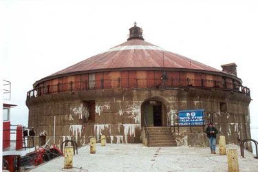
The city of Chicago, Illinois is supplied with water from Lake Michigan's "water cribs". Water cribs are offshore structures that collect water from close to the bottom of a lake in the vain hope that that water is less polluted. This then supplies a pumping station onshore, like the Edward McCotterd intake crib, here:
The first crib, the Two-Mile Crib was constructed as part of a scheme by Ellis S. Chesbrough as early as 1865.
Instead of the play on words, as in "to cheat" in getting rid of pollution issues, the name 'crib' is derived suppposedly from the function of the structure—-to surround and protect the intake shaft as it suctions out the bottom of the lake from 2 (or now 4) miles out.
Water was collected and transported through a tunnel 60 feet below the lake surface to the Chicago Avenue pumping station. Chicago's first water tunnel to the original two mile out water cribs of 1865 were completed in 1867. This tunnel of course itself two miles long, dug through clay 60 feet under lake level and was lined to a finished diameter of five feet with two shells of brick.*


An intake crib built of timber (the original two-mile crib) was located two miles off shore at the lake end of the tunnel, and the shore end was connected to a new pumping station completed in 1869. This station is the existing Chicago Avenue pumping station. This water system marked the real beginning of Chicago's water works, employing water cribs, huge under-the-lake tunnels, pumping plants, and recently, filtration and purification plants.
Even though the 1900 "flip" of the Sanitary and Ship Canal supposedly "solved" the issue there was noticably more pollution in Lake Michigan, the sewer was only piped into the "Sanitary and Ship Canal" to put the pollution "far away"--though its still there.
In the same year of 1900, the next strategy after the southwest Sanitary and Ship Canal pushed the sewer "far away" onto those living in the Mississippi River area, the same years's strategy was to "crib" the water cribs "far away" as well into the lake.
However, this to their dismay failed to stem epidemics either.
After the 1865 original, the first "far away" water crib was the Carter H. Harrison crib in 1900 (located at 41°54′59″N, 87°34′23″W). It was meant to be replaced by the William E. Dever crib, built allongside it in 1935. However, the 1900 crib continued in service beside its 1935 twin--until 1997.
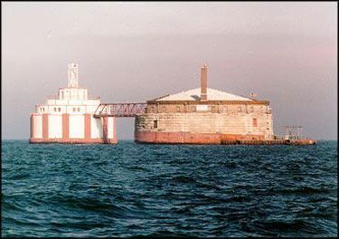
(Carter H. Harrison Crib, (1900), on the right; William E. Dever crib (1935), on its left)
It's a small world. Namesake of the 1900 crib is Carter Henry Harrison II (1860-1953), known as Carter H. Harrison. He was born in Chicago in April 23, 1860. He was the great-grandnephew of Benjamin Harrison (1726-1791), signer of the Declaration of Independence. So, your great-granduncle signs the Declaration of Independence. You get a water crib--as you slowly learn about a declaration of interdependence left out of your great-granduncles's project...
Even though the original 1900/1935 "far away cribbing" strategy failed to stop epidemics, other "even farther away" cribs kept being built--up to four miles. I have read that a good definition of insanity is doing the same thing over and over and expecting different results.
Other cribs include the Wilson Avenue crib (located at 41°57′58″N, 87°35′28″W), the Four Mile Crib (41°52′22″N, 87°32′45″W) (a cribbing even futher out...), and the 68th Street crib (41°47′10″N, 87°31′54″W).

(Wilson Avenue crib from shore)

(looking up toward the ceiling of one of Chicago's 100 year old water cribs, from the inside)
With "pollution cribbed", though the Mississippi found out that lie, Chicago keeps growing. Soon, other polltion thresholds were achieved. Next strategy was building the James W. Jardine Water Purification Plant, designed to chemically treat and filter more than a million gallons of water per minute. It went into full operation only in late 1964. There was another one from 1947, so before 1947 however, Chicago drank unfiltered lake water, still tainted with sewage?
"The [current] plant furnishes water to over 2.8 million people in the area of Chicago north of Pershing Road and certain adjacent suburban communities. Two huge tunnel systems carry water from the plant to seven pumping stations in the Central and North water districts. The South Water Purification Plant located at 79th and Lake Michigan serves the South Water District--over 1.8 million people. This plant went into service in 1947 and was later expanded to one-half the size of Jardine Water Purification Plant.
The Jardine Plant is an integral part of Chicago's vast water system which is valued at over a billion dollars. The "cribbed water system" serves a total population of more than 41 1/2 million people in an area of some 425 square miles, including Chicago and over 70 suburbs. Chicago's great Jardine Water Purification Plant, by far the largest in the world, is located on the Lake front just north of Navy Pier.*
Currently, the total plant and facilities of the system include 3 water intake cribs located about 2 miles off shore in Lake Michigan, the 2 largest water treatment (filtration) plants in the world, 11 strategically located pumping stations, and over 4,100 miles of water mains ranging in size from 4 to 60 inches in diameter.
Instead of only 60 feet below the lake suface as the original 1900 cribs, the later tunnels leading from the cribs are close to 200 feet beneath the lake and vary in shape from circular to ovular and in diameter from 10 to 20 feet. Lake water enters the cribs and flows through these tunnels to pumps at purification plants located near the shore of the lake where the water is then treated. From there it is pumped to further treatment plants and through the mains to all parts of the city as well as many of the suburbs.
Let's go full circle.
A Google Maps Tour of the Nameless Black Waterway
If you bother to take a virtual trip down this waterway and where it goes, several points are immediately raised--one among them is all that green dye goes somewhere.
Treating the environment simply as a visual backdrop and ignoring how the environment is intimately a part of your body--ignoring how bodily health, ecological health, and economic health interact--is a toxic strategy, to say the least. Can you have a public health policy while polluting the environment? Can you have a sustainable economy while polluting the environment with poor materials choices?
1. Mentioned above, the first point I noticed is that name of this waterway is unimportant--if it even has a name. The mapmakers fail to consider it important. The grids of streets are all important. Getting from A to B is more important, when the A to B quality of water flow has more effects on you (some unknown until 2005) than you imagine. The water grid of anywhere, particularly in the bioregional state is a window into both political and ecological issues and how they combine. Like much in the bioregional state, since they are combined in the real world, then governmental arrangements to be in sync with this real world should take it into account. Water, pollution runoff, and ecological clines are shared background motif regardless of one's daily life or beliefs, that ensconces us all.
2. It goes by a Vikings field.

3. That the "clean up" fails to really work. Pollution gathering thick in the 'natural' slow areas of a turn in the course of our unnamed waterway.

4. That it is an outlet for some "chillers" (air conditioning) near a major mall, which leads to lots of turbidity there, and seemingly some pollution.

5. After passing a few barges a bit further north, we come across a scrap metal barge of some kind.

6. Then a bit further south, a split in the nameless waterway, and an internal habor of sorts for barges, that seems very polluted.

7. The split in the waterway rejoins about a mile later, effectively making an island of the mid-area. This is an area with lots of other barge/transportation equipment, with lots of waiting empty semi-tractor trailers.

8. That split is very close to downtown, and the main Chicago River. Moving south from that leads to the sewer "far away" that ends up in the Gulf of Mexico.

9. Here's one of those cribs from the air.

10. Here's the "double crib" shown above, from the air.

11. And where it is in relation to Chicago, from the air.
12. And this is where the Chicago sewer has been going for 106 years--the terminus of the Mississippi River, into the Gulf of Mexico.

When "Far Away" No Longer Exists
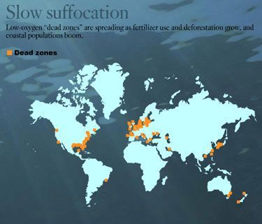
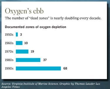
Supposedly, water diversions from the Great Lakes system are now regulated by an international treaty with Canada and by governors of the Great Lakes states. However, what about everyone downstream? Are the closer areas the only areas of importance--or are they the least important with the whole downstream gamut of the linked watersheds being the polity in question--that should have political input into such pollution? Toward a Bioregional State begins to address some of these issues. And what about the Gulf of Mexico, where dead zones are expanding?
When Cribbing Ain't Enough: "No More 'Far Away'"
The solution is "unchoosing pollution", and choosing democracy as a mechanism to support a political process that is more in sync with such bioregional, pollution, and risk assessment issues.
When there is "no more further out," the solution that stares us in the face is choosing better materials to work with in the first place, instead of institutionalizing ones that require relying on ever more "cribbed" hopes of remediation or "far away" dilution distance. The earth is almost "remediated out," since oceanic pollution is mounting. Democratizing materials choice itself is a suggested route.
And, in conclusion, providing existing democracies more with additional ecological checks and balances by fitting state institutions seamlessly into innate self-interest bioregional concerns of health, ecology, and economic sustainability is the main route Toward A Bioregional State.
So, check out the flyer summary and join me at the talk.
Cities and the Bioregional State
The book Toward A Bioregional State addresses the particuar geographic aspects of cities, as well as argues on how to add several checks and balances to enhance local political progresive movements toward sustainability--political frameworks that are historically split across multiple jurisdictions or gatekept within their own singular jurisdiction of State when they attempt more local prioritization of goals for development in their areas. What are some of the corrupt formal institutional strategies that have kept local groups from affecting policy toward sustainability?
Before we get into these, first, on the issues of cities in the bioregional state, let's look at the issue askance. Cities are closer to state/urbanist admixed phenomena--instead of simply urban population aggregating cores. Urabnization is a rural and urban human demographic scale, organizational, and commodity agglutinating phenomenon--and all three of these variables interrelate as to scale of the urban form with different physical characteristics of the materials in question, in some research of mine.
Another point that comes out of this is that there is a great deal of politics in how particular cities and commodities agglomerate and organize as an outcome whether you look at textile cities in Manchester in the 1800s or the "glocal" use of contract labor in the Third World for electronics.
In the United States, this state/urabanist political developmental phenomena particularly could be a paraphrase of the famous Hamlet quote: "to sprawl or not to sprawl, that is the question..."
So, on the one hand local areas--as seen reflected more accurately as a group in consolidated governmental areas for instance--have tended to have more progressive policies and are less ethnically or socioeconomically divisive, says the research of David Rusk, in Cities Without Suburbs.
On the other hand, you have a state and federal government that has for 100 years or more in the United States contributed toward sprawl and demoting local prioritization of funding for transportation infrastructure, which had led to incredibly corrupt Department of Transportation planning throughout the United States, frameworks (as noted in the film _Taken for a Ride) where consumers are denied public transportation choices for corporate automobile monoculture frameworks, as well as real estate subsidizations for developers against citizens on the local level or the issue of environmental justice movements of course as a truly localized defense against keeping themselves polluted and away from harm, as well as contributed toward intentionally splitting up the jurisdictions of local areas to avoid the progressivist politics of areas (noted by Rusk's research) to demote such singular feedback and wider polities of more inclusive local self interest. This is seen in the informal purposes of the "Progressive"TM movement (which was hardly progressive as far as local democracy frameworks were created actually--which saw two main strategies to demote locality from being politically powerfully expressed as an interest. The first was the intentional allowing of multiple suburb towns to have their own separate jurisdictions from the main core city, to divide and conquer up more inclusive consoliated politics of urban areas (see Urban Fortunes book for instance; as well as this was the era in which city governmental inventions such as [1] 'at large representation' (its informal strategy was to intentionally demote politically the alliance base of informal poor ward based urbanites); [2] as well as the whole "city manager" or "commission government" movement--which attempts, respectively, to change the formal institutions of city government to be a "no localist politics zone" either through the strategy of "non-partisan" appointed city executives (reading between the lines: a pro-corporate, pro-supply-side, anti-citizen participation, anti-consumer dictator), or "non-partisan commission" governments. The "no mayor" Commission governments historically have been a form of urban politics that underwrote some of the worst forms of industrial pollution, such as in Chattanooga (the most polluted city in the U.S, before 1970), before race riots of economic, social, ethnic, environmental complaint forced a governmental change of being more locally representative. And in the past 30 years, Chattanooga has become one of the cleanest of U.S. cities. Go figure.
In other words, when you in your mind think of "cities," remember to think of how the formal institutional governmental factors of cities influence the direction of developmetnalism and representaion in cities, and what biases it demotes or engenders.
I can think of six main historical strategies of formally rigging democratic feedback to demote representative bioregional politics that have been used in the United States--as well as in other countries.
A formally environmentally degradative U.S.--and many other countries--are run this way:
[1] if you dislike someone else's political base of grassroots feedback into politics--whether urban or rural--simply attempt to divide it up informally as elections come along on a wedge issue,
[2] electorally gerrymander it out of existence by formal district changes to demote political districts that are competitive
[3] state border gerrymander (draw the state lines) in such a way as to split inclusive urban jurisdictions,
[4] steal elections somehow,
[5] attempt to take certain forms of local jurisdiction out of their hands altogether,
[6] or "vote rules gerrymandering"--via forms of balloting access that demotes the creation of durable competitive parties, demotes fusion potentialities, and demotes durable third parties, the latter being the only informal check and balance toward a competitve democracy; unsustainability is connected with organizing vote frameworks to allow minority parties to masquerade as majority parties since they have vote gerrymandered frameworks into existence against the participation of the full electorate, without the the full electorate being cabable of organizing. (In the United States, this started in the 1870s and was "complete" by the 1896 elections, and voting particiaption due to vote gerrymandering that demoted competitive parties, has remained since 1896 the lowest for any self-proclaimed democracy, barely cresting 50% for a century or more. The bioregional state would recommnend "PRMA" to counter this, which is proportional representation with a majoritarian allotment, described in the book to force parties to compete for 100% of the electorate instead of merely compete for a partial electorate and ignore the rest.)
Sustainabilty and Local Representation Versus "Dillon's Rule": Remove It
Sustainability and Local Representation Versus Gerrymandered Divide and Conquered Geographies: Group Them
I'll concentrate on two of these below.
One of the first type of strategies to demote local jurisdictional interests into policy and formal institutional democracy is the U.S.'s intentionally split 'suburban governments'--made very easy in the early 1900s to take away the tax base and demote local political financial or inclusive political clout in expanding cities--replacing it with various autarkic governmetnal institutions in urban areas and "urban apartheid" areas of the U.S. that are seen everywhere. [1, 2, 3, 4, 5, 6] (see Urban Fortunes).
One of the latter fifth strategies in the U.S. is called "Dillon's Rule"--which I will concentrate on here to the neglect of the other four, though all are equally imporant, since one of the points of Toward a Bioregional State is to call attention to the delimited, corrupt, and gatekeeping purposes of what has passed so far as "formal democratic institutions" which have only generated conditions of unsustainability and poor examples of democracy themselves.
This practice of intentionally gatekeeping against local jurisdictional input is the purpose of the U.S.'s "Dillon's Rule".
Another factor that contributes to demoting local jurisdictional input would be the (first listed issue) gerrymandering issue, as well as the historical ways State lines were drawn actually.
All these issues demote inclusive urban or rural local political input into States and their democratic policy machinery. The little clout in how local areas have been able to have local jurisdictional priority in their developmental policies has been absolutely intentional--designed this way for over 100 years in the United States. (I may come back and address the other points here, though for the present...)
1. One point comes back to "Dillon's Rule"--an an 1870s humanocentric view and State corporatist view on urban issues, versus a bioregional view.
"John Forrest Dillon (December 25, 1831 – May 6, 1914) was an American jurist who served on both federal and Iowa state courts, and who authored a highly influential treatise on the power of states over municipal governments. Dillon studied medicine at Iowa State University at the age of 19. Shortly after beginning his practice, he abandoned it to study law and was admitted to the Iowa bar in 1852. He was elected as the Scott County prosecutor after a brief private practice in 1853, and was then elected to a judgeship in Iowa's 7th Judicial Circuit in 1858. He was elevated to the Iowa Supreme Court in 1862 and served until 1869, when he was appointed by President Grant to the Eighth Circuit. While on the federal bench, Dillon wrote Municipal Corporations (1872), which was one of the earliest treatises to systematically study the subject. Dillon argued that in contrast to the powers of states, which are unlimited but for express restrictions under the state or federal constitution, municipalities only have the powers that are expressly granted to them--by the States."
However, what if the States that Dillon trusts are even more corrupt frameworks of power than the urban cores that concerned him, and framed legal cases to repress their State internal political adversaries for their informal political goals? The concern in a bioregional state view as well is that such State (corporatist) governments--which were the actual frameworks of "State" governments from this era, as noted in books like Unequal Protection and The Incorporation of America, were captive of certain financial and commercial private concerns--which were making policy over public municipal corporations.
The actual, local, consumer, and citizen concerns of politics were entirely gatekept against, gatekept on the corporatist State level against local democratic concerns in general. This was and is particularly when it comes to urban pollution issues or food issues. Remember how contentious the 1906 Pure Food Act was, that created the Food and Drug Administration. (And remember out of that how repressive such centralized power over foods can be as well, when captured by corporate interests. Certainly a more watershed specific priority of jurisdition over development would be prefereable for all truly public minded concerns?
Bioregional democracy (or the Bioregional State) is a set of electoral reforms (and commodity reforms) designed to force the political process in a democracy to better represent concerns about the economy, the body, and environmental concerns (e.g., water quality), toward developmental paths that are locally prioritized and tailored to different areas for their own specific interests of sustainability and durability. This denotes democratic control of a natural commons and local jurisdictional dominance in any economic developmental path decisions--while not removing more generalized civil rights protections of a larger national state.
Back to Dillon in the 1870s when Chicago water cribs were only around 10 years old. It's past time to challenge such one sided rulings like Dillon's, particularly in reference to how they contribute toward risk expansion on the local level against those attempting to work toward sustainability.
"Dillion's formulation of the scope of municipal power came to be known as the "Dillon Rule," which states that municipal governments only have the powers that are expressly granted to them by the state legislature, those that are necessarily implied from that grant of power, and those that are essential and indispensable to the municipality's existence and functioning. Any ambiguities in the legislative grant of power should be resolved against the municipality so that its powers are narrowly construed. However, when the state has not specifically directed the method by which the municipality may implement its granted power, the municipality has the discretion to choose the method so long as its choice is reasonable.
"Hundreds of U.S. court decisions to the present day have employed the Dillon Rule to determine the scope of municipal powers and rights. Critics of the Rule have argued that it imposes unreasonable constraints on the ability of communities to govern themselves and so undermines democracy, and even that local self-government is a matter of natural right that does not need to be conferred by higher political structures. It has also been suggested that Dillon's approach derived from the contemporary view that cities were inherently corrupt political organs. This was perhaps an often well-deserved judgment during his time, especially considering the extensive business ties and even investments of numerous cities and their leaders in the late 19th century.
"The Supreme Court of the United States cited to Municipal Corporations and fully adopted Dillon's emphasis on state power over municipalities in Hunter v. Pittsburgh, 207 U.S. 161 (1907), which upheld the power of Pennsylvania to consolidate two cities against the wishes of the majority of the residents in one. The Court's ruling that states could alter or abolish at will the charters of municipal corporations without infringing upon contract rights heavily relied upon Dillon's separation of public, municipal corporations from private ones."
I would argue Dillon's rule requires an additional check and balance because of a blind spot.
If Dillon's concern was for controlling the jurisdiction over corrupt cities, it is equally the urban concern for controlling jurisdiction over corrupt States. Thus, one solution would be to make urban issues instead federal issues instead of simply State ones.
1a. If corporations are going to be given citizenship rights in a federal venue, the certainly public municipal corporations deserve to be treated as equals, instead of the legal "second class" caste framework in place presently against them where they only have State rights of citizenship, so to speak.
1b. Corrupt State governments were a huge oversight of Dillon here. Instad, both should check each other, particularly on increasing concerns over environmental degradation and externalities experienced by local groups.
1c. Another argument for cities with federal rights instead of merely State rights is geographic reality. Most conurbations in the United States are border phenomena. Due to how urbanization tends to agglomerate at mountain passes, river fordings, and other transportation or junction nodes, combined with how much of the line drawing of the abstract states of the world have drawn themselves down the middle of watersheds, by using rivers as boundary lines for instance in many cases, this tends to place urbanization across split jurisdictions--across multiple states. There is a whole chapter in Toward a Bioregional State devoted to plumbing this information. Wisconsin for example has most of its major cities as cross-border phenomena or lakefronted examples, instead of internalized to the state. So giving urban areas only state jurisdictional rights ignores that the transportation and urban networks typically in the United States (and worldwide) are larger territorial state/federal issues, and it additionally divides up progressive local politics (as noted in Rusk's book).
1d. If Dillon's Rule had anachronistically existed in European history, or in Greece for that matter, there would certainly be nothing called democracy ever. It would be against Dillon's Rule. The world would look like Prussia--with the State being its own degradating justification and own end--instead of a means toward sustainability, justified off protecting individual liberties, civil rights, consumer rights, union rights, environmental rights, local bioregional developmental rights, rights of assembly--in short, where citizens have input into the government and its developmental policies for their particular areas.
The whole raison d'etre of democracy ties in with sustainability one might say in the the affirmitive pressures of feedback from those externalized in cities--and in rural areas to make their locales better places: more healthful, more ecologically sound, and more economically sustainable.
To gatekeep against that localized politics, in jury-rigged "Dillon Rule" slap suits, is to shun a very ecological and progressive form of politics. To gatekeep against these localized politics is to foment environmental degradation.
It is to design States for unsustainabily and self-destruction to follow Dillon's Rule.
2. For the second type of localist gatekeeping, on the issue of state/urbanist politics, this gets into another "split politics" issue of the interactive effect of large urban areas halved by State line drawing:
2a. Large cities politically are typically nodes that readily organize those externalized economically. Cities tend to have a very progressive ASCRIPTIVE SOCIAL and ECONOMIC ORGANIZATIONAL gloss of institutions and civil rights protections supported and self generated by the readily organized externalized groups of societies in urban areas. Much of the U.S. leftist politics and civil rights politics comes from in some form (unless e-vote fraud entrudes) urban based politics in origin.
2b. However, at the same moment, large cities however tend to be state/politically organized in consumtive relationships of consumer clientelism which has a political support for regressive ENVIRONMENTAL developmental pathways--for environmental degradation support. Thus, 2a and 2b happen at the same moment, typically. It fails to happen in all cases, for example in Porto Alegre, in Rio Grande Du Sul, Brazil, though exceptions prove the rule I would argue.... In the U.S. Dillon's Rule's gerrymander against local bioregional politics fails to help either. Typically state politics or consumer urbanist politics around the environment areas is much harder to durably organize consumer institutions that are ecologically sound in an urban venue where there is so much that is "permanently transitory" about consumption in cities. Even if social and economic organizational politics may be progressive in cities, and cities as a force in states for such policies, the state/urbanist alliance politics has tended to be readily organized as environmentally degradative regardless.
One way to interrupt this would be to have the more singular jurisdictions that would allow such political feedback that already exists to get past Dillon's Rule style forms of gatekeeping, toward allowing local municipal corporations more local economic decisions on their instituitons, instead of facing State vetos without cause. Another way to interrupt this would be to put urbanized aras within singular cross-state jurisdictions when the situation warrants. Both are recommendations in the bioregional state.
Thus one check and balance within the bioregional state addresses this border-city phenomena difficulty--a difficulty that runs circles around such simplisms of Dillon's Rule interpretations. Getting into that discussion is hardly the point here however. For a quick summary it has to do with the bicameral representation putting cities, states, and federal level power networks in mutual check and balance arrangements. It depends upon full watershed representation in relation to cities, where one house of a state votes full watershed as the polity, one house the contiguous border (split urban) polity, so there are innately overlapping areas, inclusive of cross-border border areas which will be more politically and ecologically progressive as a result of grouping this demographic innately in the lower House. You can read it in the book for more.
3. As for the intentional jurisdictional autarky" or divide and conquer politics instituted at the beginning of the 1900s around urban areas, the opposite is important to inclucate: putting all these local political areas inclusively in the same jurisdiction--particluarly the same watershed jurisdiction--is paramont. This is so that economic path decisions can more locally reflect concerns about health, ecology, and economic risk in its developmental choices, instead of being "State-designed" from afar into the urban area. Therefore, such contexts would automatically trumps frameworks as Dillon's rule which have held open state supported sprawl subsidization for 100 years for pro-corporate State governments instead of public concerns of localities. This has had disasterous consequences on many social, ethnic, developmental, as well as even bodily effects of the U.S. popluation. The health of the U.S. population have recently shown "sprawl makes people fat"--a statistically sound variable influencing body weight is the scale of the measurement of sprawl of the city in which one lives. One could add in the health of its environment, or the health of its economy (the excessive expenses of transportation for example in sprawled areas). The irony is that people, when queried with images of what kind of cities they would prefer to live in, dislike such specialized use policies of cities and pick mixed use city scales--that mostly "can't be built" under present U.S. laws. Go figure.
4. The first strategy of "environemntal gerrymandering" issues of political districts is another issue--that will be addressed at a later date in a blog entry all to itself. Environmental gerrymandering is conducted historically by both the Democratic and the Republican party to demote competitive party contexts that make the voter's worth more meaningful. One of the most recent examples is the election of a competitive Green Party candidate to the Maine State Legislature. Immediately, the Democratic party regerrymandered the districts in an attempt to remove his vote base out from under him. Even though he was an elected representative, he was denied Congressional office space. I hope people keep in mind that both the current Democratic and the Republican parties are wholly corrupt Frankenstein monster cobbled together from various dead ideas, environmetnal gerrymandering, urban gerrymandering, etc. However, one of the points of the bioregional state is that the hegemony of these completely uncompetitive parties is due to formal institutional issue dynamics, which can be changed to faciliate more competitive party politics as well as politics that appeals to the full electorate instead of agreeing to collude for the partial electorate (which is the common strategy of the Democratic and Republican parties).
These are just some of the issues I keep in mind when I think of large cities. [1, though his "GM" standpoint sounds like he's been paid off, and he ignores the supply-side biased appliations of every example of GM technology that has ever been; and his flouride stance is unscientific and fails to really explain how there are so many other choices to purify water]; [2]
Taking a quote from the link above, the monotonic assumptions of the "Population Bomb" Theory seems to be a dud: World Population has been stabalizing since 2002 and dropping below replacement naturally already--and it has a lot to do with the sociology of larger urbanized populations, percentagewise.
This quote from the author editor of the Whole Earth Catalogue
"Take population growth. For 50 years, the demographers in charge of human population projections for the United Nations released hard numbers that substantiated environmentalists' greatest fears about indefinite exponential population increase. For a while, those projections proved fairly accurate. However, in the 1990s, the U.N. started taking a closer look at fertility patterns, and in 2002, it adopted a new theory that shocked many demographers: human population is leveling off rapidly, even precipitously, in developed countries, with the rest of the world soon to follow. Most environmentalists still haven't got the word. Worldwide, birthrates are in free fall. Around one-third of countries now have birthrates below replacement level (2.1 children per woman) and sinking. Nowhere does the downward trend show signs of leveling off. Nations already in a birth dearth crisis include Japan, Italy, Spain, Germany, and Russia -- whose population is now in absolute decline and is expected to be 30 percent lower by 2050. On every part of every continent and in every culture (even Mormon), birthrates are headed down. They reach replacement level and keep on dropping. It turns out that population decrease accelerates downward just as fiercely as population increase accelerated upward, for the same reason. Any variation from the 2.1 rate compounds over time.
That's great news for environmentalists (or it will be when finally noticed), but they need to recognize what caused the turnaround. The world population growth rate actually peaked at 2 percent way back in 1968, the very year my old teacher Paul Ehrlich published The Population Bomb.
The world's women didn't suddenly have fewer kids because of his book, though.
They had fewer kids because they moved to town.
Cities are population sinks-always have been. Although more children are an asset in the countryside, they're a liability in the city. A global tipping point in urbanization is what stopped the population explosion. As of this year, 50 percent of the world's population lives in cities, with 61 percent expected by 2030. In 1800 it was 3 percent; in 1900 it was 14 percent.
The environmentalist aesthetic is to love villages and despise cities. My mind got changed on the subject a few years ago by an Indian acquaintance who told me that in Indian villages the women obeyed their husbands and family elders, pounded grain, and sang. But, the acquaintance explained, when Indian women immigrated to cities, they got jobs, started businesses, and demanded their children be educated. They became more independent, as they became less fundamentalist in their religious beliefs. Urbanization is the most massive and sudden shift of humanity in its history. Environmentalists will be rewarded if they welcome it and get out in front of it. In every single region in the world, including the U.S., small towns and rural areas are emptying out. The trees and wildlife are returning. Now is the time to put in place permanent protection for those rural environments. Meanwhile, the global population of illegal urban squatters -- which Robert Neuwirth's book Shadow Cities already estimates at a billion -- is growing fast. Environmentalists could help ensure that the new dominant human habitat is humane and has a reduced footprint of overall environmental impact.
Even with population agglomerating in cities more and more and population dropping, that
[1] fails to mean that the organization of the political support of environmetnal degradation (2b, mentioned above) will be demoted without more affirmive politics suggested in the bioregiounal state. Otherwise, the corrupt gatekeeping on politics from such areas and the ongoing protected political development toward unsustainability will continue.
[2] Pollution demotes breeding fitness capacities in general, as well. That is left out of the above quote. The issue however is how low will it go "naturally"--with increasing pollution destroying human sex hormones and reproductive capacities, and precipitiously dropping sperm counts in humans that has been drastically noted in all world surveys?
In other words, there should be a war on pollution and polluters, instead of killing off the population suffering and complaining about the pollution. The only war that is legitimate is a war for against unsustainabilty, and the very small highly politically connected corporations and corrupt states and state militaries. Some of the world's largest polluters, are militaries--instead of private corporations.
Since it has been reported that half of the world will live in large cities by 2007, a bioregional state view that fails to take into account that there is a civil governmental aspect of urban and rural areas that influences their developmental direction, will be as willfully blind as Dillon's Rule or other forms of environmental gerrymandering on long term developmental biases that are unwittingly (or wittingly, with corruption) formulated.
posted by Mark at 1:52 AM
1 comments
![]()
![]()
